Creating a game plan
As a best practice, consider the following questions before you configure a delivery area:
- Where will you gather the map data for your delivery area? Will you use the Map Pack option?
- If you choose not to use the Map Pack option, is there an import file available for streets? If not, can you create an import file, or will you manually enter each street in the Delivery Areas function?
- Will your site use zones for delivery fees or dispatch organization? If so, what are the zones?
- Will you use neighborhoods, and, if so, will the neighborhoods be a part of a zone (not required)? Map out each neighborhood so that you know to which zone each neighborhood belongs.
Planning your delivery area
There are several options and combinations from which to choose when defining a delivery area:
-
Use Map Pack and the new delivery area configuration tool.
Pro: The process is quick and easy to use. The delivery area configuration tool allows you to easily define your delivery area with a paint brush configuration tool and then import the addresses into your delivery area. You can further divide your delivery area into zones using the same paint brush functionality and define delivery fees by zone. Map Pack data includes city, state, and ZIP code information, which is useful for the 'type-ahead address' functionality and tax by locale, when configured.
Con: You cannot use the paint brush utility tool to create neighborhoods.
-
If you are an existing Delivery/Frequent Buyer site and upgrading to Aloha Takeout, import the delivery area data file (Zone.txt) into Aloha Takeout.
Pro: The delivery area data file (Zone.txt) includes zone information for each street. Once imported, ATO creates the zones and adds each street to the correct zone.
Con: While the delivery area data file (Zone.txt) includes zone information, it does not include city, state, and ZIP code information. You can define a default city, state, and ZIP code in Takeout Settings > Customer Information that applies to all addresses. Additionally you can define a city, state, and ZIP code for a zone, neighborhood, or street in the Delivery Areas function. ATO applies the city, state, or ZIP code to an address based on the highest level you defined, with street being the highest level and default being the lowest.
-
Purchase an address list, in a format you can import into Aloha Takeout, from MelissaData.com.
Pro: The delivery area data (StreetAddresses.csv) includes city, state, and ZIP code information. This is useful for the 'type-ahead address' functionality.
Con: There is a cost associated with this, and even though the import includes city, state, and ZIP code information, it does not include zone information. If you require zone functionality, you must manually create zones in ATO and drag each street to the zone in which it is located. Depending on the size of your delivery area, this task can be very time consuming.
-
Work with a geographical information system (GIS) company to develop a delivery area and map.
Pro: Does not require any work on the part of the site, but you need to first confirm that the GIS company can provide the delivery area data in one of the defined import file formats.
Con: This can be expensive. Depending on the delivery area file format the GIS company creates, the same cons for Zone.txt or StreetAddresses.csv exist.
-
Manually create a delivery area either by creating StreetAddresses.csv or Zone.txt and then import the file into Aloha Takeout by using the Delivery Areas function in Aloha Takeout.
Pro: Manually creating a delivery area does not require you purchase service or data from another company.
Con: Manually creating a delivery area can be very time consuming. This requires you to drive your delivery area, use a map, or use the Internet to determine the streets and street numbers in your delivery area, then manually enter the delivery information. You may find it easier to use MS Excel or Notepad to enter the data and then import the file into ATO.
Note: Whichever method you use to create the delivery area, ATO uses the starting and ending house number range on a street to determine if a new address is within the delivery area and assumes all addresses within the range are valid.
Delivery area components
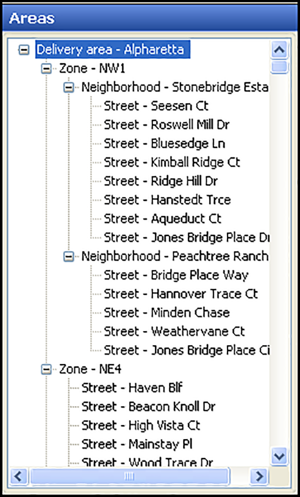
A delivery area is made up of streets. You may also define zones and neighborhoods, for additional grouping or functionality.

Streets (Required) — Your delivery area must include streets to associate with customers and provide a delivery address for drivers. ATO supports sub-dividing a long street when it extends across a zone or neighborhood boundary.
You can also specify if you deliver to the odd, even, or both sides of a street.
Neighborhood (Optional) — A logical grouping of streets. Although ATO does not associate routing or address logic with neighborhoods, they provide another layer to help you organize a vast delivery area into more manageable blocks. In most cases, we recommend you do not configure neighborhoods unless you need them for this reason.
Zone (Optional) — A logical grouping of streets and neighborhoods. It is up to you to determine the shape, name, contents, and delivery fee of a zone. Geographical obstacles, distance radius, drive time, and general compass direction are commonly used to define zone boundaries and content.